Always check for road closings from hurricane flooding damage, ice or high winds on the Blue Ridge Parkway. Call (828) 298-0398 to determine if the Blue Ridge Parkway is accessible before attempting to drive to Alpine Village Townhomes from Asheville via this particular route.
From Asheville, it is about the same distance whether you travel east on I-40 to Old Fort and take the US 70 exit towards NC 80 leading to Alpine Village (the twisty, climby route), or if 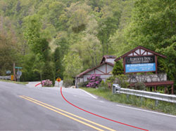 you travel north from Asheville on I-26 (US 19/23), then take 19E east through Burnsville, then NC 80 south at Micaville towards Alpine Village (a much gentler route).
If you come by way of Burnsville, you might want to pick up groceries at Ingles or any of the other grocery stores in town before continuing to Alpine Village. We are thirty minutes from town.
If you are traveling from Tennessee, take I-26 (US 23) southwest out of Johnson City going towards Asheville. After crossing the Tennessee/NC state line you should turn at the intersection with 19E going towards Burnsville. Again, just east of Burnsville, you can pick up NC 80 at Micaville going south towards Alpine Village.
 We do not recommend taking the Blue Ridge Parkway during rain or low-hanging clouds as the area passing Mt. Mitchell can get fogged in and treacherous. If you do take the parkway, exit at Buck Creek Gap, milepost 344, and travel north towards Burnsville on NC 80.
DIRECTIONS ONCE YOU ARE RIDING ON NC 80:
FROM BURNSVILLE traveling northeast on US 19E, turn right onto NC 80 South at Micaville heading south. Travel about 12 miles until you pass the Mt. Mitchell Golf Course. Just after the Golf Course and Albert’s Inn & J J’s Grill On the Green Restaurant (see above), turn right onto the South Toe River Road. There is a large brown sign “WELCOME to our COMMUNITY”.
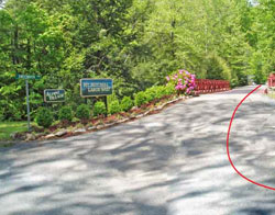
Travel about 9/10 of a mile and turn right across a red iron bridge. If you are traveling on gravel, you’ve missed the turn. After crossing the red iron bridge follow the main road, Sweetwater Ridge, pass the lake on the left and several speed bumps. The road changes to Overlook Drive on up to Alpine Village. DO NOT TAKE LAUREL Dr.
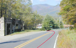 DIRECTIONS FROM ASHEVILLE via I-40: Take I-40 eastbound from Asheville exiting at OLD FORT onto US 70 eastbound toward Marion. Travel about 9 miles along US 70 until you come to an intersection (with a traffic light) for NC 80. If you need groceries, go another 2 miles on US 70 to the Food Lion, and then double back to NC 80. Turn on NC 80 and travel UP INTO THE HILLS on a very winding road. After about 12 miles on this route you will pass UNDER the Blue Ridge Parkway. Continue on NC 80 another 2 miles or so, you will pass Mount Mitchell Baptist Church, go another 1/2 mile and turn left just PAST a small square stone building (see above) onto a paved road with signs indicating “Black Mountain Campground.” This is South Toe River Rd.
You will see a large brown sign “WELCOME to our Community”. Turn here onto South Toe River Road, about 9/10 of a mile. You will turn right across a rust steel bridge – we also have an Alpine Village sign at this area. If you are traveling on gravel, you’ve missed the turn. After crossing the RUST IRON BRIDGE, follow the main road (Sweeterwater Ridge) past the lake, crossing several speed bumps. The road changes to Overlook Dr. up to Alpine Village. DO NOT TAKE LAUREL Dr.